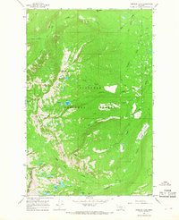
1965 Map of Hemlock Lake
USGS Topo · Published 1968About this map
Flathead National Forest land defines this section of the Mission Mountains as it was mapped in the mid-1960s. The landscape is characterized by a high-elevation drainage system feeding into Elk Creek, with numerous alpine lakes including Hemlock Lake, Cheff Lake, and Island Lake clustered near the Missoula County line. The terrain is marked by prominent summits such as Red Butte and Hemlock Point, which oversee a network of Pack Trails that provided the primary means of access through these woods before modern road development.
Find a feature on this map
30 named features on this map. Tap any name to fly to it.
Don’t see what you’re looking for? This feature index may not catch every label — zoom into the map to look around manually.
Map Details
Editions of this 1965 Hemlock Lake Map
This is the sole edition of this map. No revisions or reprints were ever made.
Other maps of this area

1921 · Elbow Lake
USGS Topo · 1:125,000

1955 · Choteau
USGS Topo · 1:250,000

1957 · Choteau
USGS Topo · 1:250,000

1958 · Choteau
USGS Topo · 1:250,000

1962 · Choteau
USGS Topo · 1:250,000

1965 · Peck Lake
USGS Topo · 1:24,000

1965 · Condon
USGS Topo · 1:24,000

1965 · Gray Wolf Lake
USGS Topo · 1:24,000

1965 · Lake Marshall
USGS Topo · 1:24,000
1965 · St Marys Lake
USGS Topo · 1:24,000