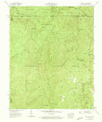
1959 Map of Hemp Top
USGS Topo · Published 1973About this map
Jacks River and the Conasauga River carve through this high-elevation mountain terrain where the Tennessee and Georgia state lines meet. The landscape is defined by the massive tracts of the Cherokee National Forest and the Chattahoochee National Forest, overseen by the Ocoee Wildlife Management Area and the Rough Ridge Wildlife Management Area. This 1959 field examination shows a region focused on conservation and forestry, with limited human development clustered near the gaps and river bottoms. Local history is preserved in small landmarks such as Bethlehem Ch and Jones Cem, while the industrial past of the mountain is hinted at by the Founding Mill Creek and an area of Ruins south of the Fork. High peaks like Buckeye Mountain and Hemp Top, which features a Lookout tower, provide significant vantage points across this preserved wilderness.
Find a feature on this map
69 named features on this map. Tap any name to fly to it.
Don’t see what you’re looking for? This feature index may not catch every label — zoom into the map to look around manually.
Map Details
Editions of this 1959 Hemp Top Map
4 editions found
Other maps of this area

1886 · Dalton
USGS Topo · 1:125,000

1886 · Cleveland
USGS Topo · 1:125,000

1888 · Ellijay
USGS Topo · 1:125,000

1892 · Cleveland
USGS Topo · 1:125,000

1892 · Ellijay
USGS Topo · 1:125,000

1892 · Dalton
USGS Topo · 1:125,000

1893 · Murphy
USGS Topo · 1:125,000

1895 · Cleveland
USGS Topo · 1:125,000

1897 · Dalton
USGS Topo · 1:125,000

1898 · Ellijay
USGS Topo · 1:125,000