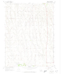
1958 Map of Hendley
USGS Topo · Published 1974About this map
Hendley stands as the primary settlement in this corner of Furnas County during the late 1950s, situated along the southern edge of the landscape near the Chicago Burlington and Quincy railroad line. The map illustrates a rural Nebraska territory organized into distinct townships including Vincent, Union, Lynden, and Eureka. The topography is defined by the drainage patterns of Beaver Creek and several unnamed tributaries that have carved the rolling terrain.
Find a feature on this map
11 named features on this map. Tap any name to fly to it.
Don’t see what you’re looking for? This feature index may not catch every label — zoom into the map to look around manually.
Map Details
Editions of this 1958 Hendley Map
2 editions found
Other maps of this area

1896 · Arapahoe
USGS Topo · 1:125,000

1898 · Arapahoe
USGS Topo · 1:125,000

1954 · McCook
USGS Topo · 1:250,000

1955 · Grand Island
USGS Topo · 1:250,000

1957 · McCook
USGS Topo · 1:250,000

1957 · Grand Island
USGS Topo · 1:250,000
1957 · Beaver City SW
USGS Topo · 1:24,000
1957 · Wilsonville
USGS Topo · 1:24,000

1957 · Beaver City SE
USGS Topo · 1:24,000

1958 · McCook
USGS Topo · 1:250,000