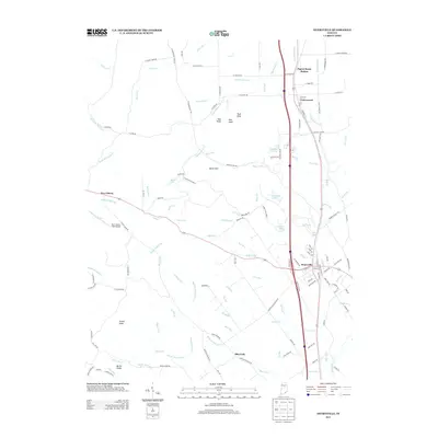
2013 Map of Henryville
USGS Topo · Published 2013About this map
The town of Henryville serves as the central hub of this Indiana landscape, situated along the corridor of Interstate 65. The map illustrates a transition from the structured street grids of Underwood and Pigeon Roost Station to the complex topography of the Clark State Forest. Significant elevation changes are marked by distinct peaks such as Oak Knob, Pine Knob, and Round Knob, while the southern reaches are defined by the Bartle Knobs. Drainage patterns are extensive, with Silver Creek and the Underwood Drain moving water through the eastern flats, while Pigeon Roost Creek carves through the Silver Hills. Local aviation is represented by the New Liberty Field Airport, and several bodies of water, including Schlamm Lake, Franke Lake, and Big Bass Lake, are clustered in the central wooded areas. This survey captures a mix of timbered uplands and established settlements in Clark County.
Find a feature on this map
150 named features on this map. Tap any name to fly to it.
Don’t see what you’re looking for? This feature index may not catch every label — zoom into the map to look around manually.
Map Details
Editions of this 2013 Henryville Map
This is the sole edition of this map. No revisions or reprints were ever made.
Other maps of this area

1905 · Prospect
USGS Topo · 1:62,500

1912 · Prospect
USGS Topo · 1:62,500

1937 · Charlestown
USGS Topo · 1:24,000

1938 · Speed
USGS Topo · 1:24,000

1941 · Borden
USGS Topo · 1:24,000

1947 · Speed
USGS Topo · 1:24,000

1947 · Scottsburg
USGS Topo · 1:24,000

1949 · Henryville
USGS Topo · 1:24,000
1950 · Charlestown
USGS Topo · 1:24,000

1955 · South Boston
USGS Topo · 1:24,000