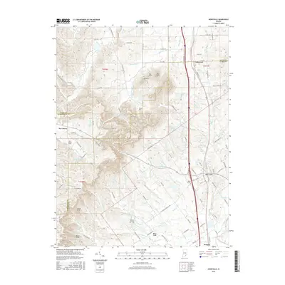
2016 Map of Henryville
USGS Topo · Published 2016About this map
Henryville serves as a central hub on this Clark County landscape, where the confluence of road and rail networks meets the rising terrain of the Silver Hills. The Interstate 65 corridor bisects the quadrangle, passing through Underwood and Memphis, while older routes like Railroad St and Henryville Bluelick Rd hint at the area's deeper transportation history. To the west, the topography shifts into the prominent peaks of Oak Knob, Pine Knob, and the Bartle Knobs, marking a distinct boundary between the agricultural flats and the wooded highlands. Researchers can find numerous family and community landmarks, including the Mount Zion Cem near Henryville and the Mountain Grove Cem tucked away near Blue Lick. Several man-made water bodies, such as Franke Lake and Schlamm Lake, illustrate the development of local water management and recreation across these southern Indiana townships.
Find a feature on this map
121 named features on this map. Tap any name to fly to it.
Don’t see what you’re looking for? This feature index may not catch every label — zoom into the map to look around manually.
Map Details
Editions of this 2016 Henryville Map
This is the sole edition of this map. No revisions or reprints were ever made.
Other maps of this area

1905 · Prospect
USGS Topo · 1:62,500

1912 · Prospect
USGS Topo · 1:62,500

1937 · Charlestown
USGS Topo · 1:24,000

1938 · Speed
USGS Topo · 1:24,000

1941 · Borden
USGS Topo · 1:24,000

1947 · Speed
USGS Topo · 1:24,000

1947 · Scottsburg
USGS Topo · 1:24,000

1949 · Henryville
USGS Topo · 1:24,000
1950 · Charlestown
USGS Topo · 1:24,000

1955 · South Boston
USGS Topo · 1:24,000