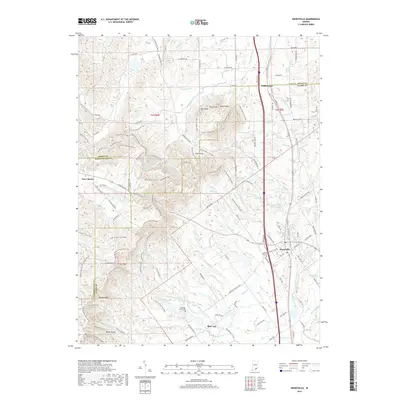
2019 Map of Henryville
USGS Topo · Published 2019About this map
Henryville and Underwood anchor this detailed topographic survey, which spans the border of Scott and Clark counties. The local landscape is defined by the significant elevation of the Bartle Knobs and several notable heights including Pine Knob, Oak Knob, and Rock Knob. These features provide a rugged backdrop for the extensive Clark SF Horse Trails and the Knobstone Trail, which navigate the ridgelines and valleys north of New Liberty.
Find a feature on this map
143 named features on this map. Tap any name to fly to it.
Don’t see what you’re looking for? This feature index may not catch every label — zoom into the map to look around manually.
Map Details
Editions of this 2019 Henryville Map
This is the sole edition of this map. No revisions or reprints were ever made.
Other maps of this area

1905 · Prospect
USGS Topo · 1:62,500

1912 · Prospect
USGS Topo · 1:62,500

1937 · Charlestown
USGS Topo · 1:24,000

1938 · Speed
USGS Topo · 1:24,000

1941 · Borden
USGS Topo · 1:24,000

1947 · Speed
USGS Topo · 1:24,000

1947 · Scottsburg
USGS Topo · 1:24,000

1949 · Henryville
USGS Topo · 1:24,000
1950 · Charlestown
USGS Topo · 1:24,000

1955 · South Boston
USGS Topo · 1:24,000