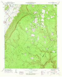
1946 Map of Henson Gap
USGS Topo · Published 1974About this map
Walden Ridge and the Cumberland Escarpment define the geography of this mid-century survey, creating a dramatic vertical divide between the Sequatchie Valley and the high plateaus. The Sequatchie River meanders through the lowlands to the northwest, paralleled by the Alvin C York Highway, while the uplands show a more dispersed pattern of settlement. Here, the community at Lewis Chapel serves as a focal point, supported by the Lewis Chapel Sch and Elder Ch. Cultural markers like Stewart Camp and the Davis Cem suggest the long-standing family ties of this landscape. The transition from the valley floor to the ridges is marked by a series of steep gaps, including Henson Gap and Walnut Gap, which have historically dictated the movement of people and resources between these distinct environments.
Find a feature on this map
74 named features on this map. Tap any name to fly to it.
Don’t see what you’re looking for? This feature index may not catch every label — zoom into the map to look around manually.
Map Details
Editions of this 1946 Henson Gap Map
4 editions found
Other maps of this area

1888 · Chattanooga
USGS Topo · 1:125,000

1893 · Chattanooga
USGS Topo · 1:125,000

1935 · Daisy
USGS Topo · 1:24,000

1935 · Soddy
USGS Topo · 1:24,000

1935 · Brayton
USGS Topo · 1:24,000

1935 · Mount Airy
USGS Topo · 1:24,000

1936 · Daus
USGS Topo · 1:24,000

1936 · Henson Gap
USGS Topo · 1:24,000

1936 · Ketner Gap
USGS Topo · 1:24,000

1936 · Fairmount
USGS Topo · 1:24,000