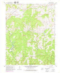
1960 Map of Herd
USGS Topo · Published 1979About this map
Oil and gas development defines this 1960 landscape within Osage County, where numerous Oil Wells and Gas Wells are scattered throughout the Caney and Strike Axe districts. The settlement of Herd sits along the northern edge, connected to the surrounding topography by an Old Railroad Grade that once facilitated the movement of resources through the region. In the south, the establishment of Osage Hills State Park protects a portion of the terrain near Horseshoe Bend. The hydrology is marked by several small impoundments including Deer Lake, Sunset Lake, and Spring Lake, which break the drainage patterns of Rock Creek and Mission Creek. Local history is anchored by the Bigheart locality and a rural Cem, providing tangible points of interest for genealogists tracking family roots in this corner of the state during the mid-twentieth century.
Find a feature on this map
21 named features on this map. Tap any name to fly to it.
Don’t see what you’re looking for? This feature index may not catch every label — zoom into the map to look around manually.
Map Details
Editions of this 1960 Herd Map
4 editions found
Other maps of this area

1906 · Nelagoney
USGS Topo · 1:24,000

1909 · Pawhuska
USGS Topo · 1:125,000

1910 · Pawhuska
USGS Topo · 1:125,000

1955 · Enid
USGS Topo · 1:250,000

1958 · Enid
USGS Topo · 1:250,000

1960 · Nanos
USGS Topo · 1:24,000

1960 · Nelagoney
USGS Topo · 1:24,000

1960 · Herd
USGS Topo · 1:24,000

1960 · Pawhuska
USGS Topo · 1:24,000
1971 · Bowring
USGS Topo · 1:24,000