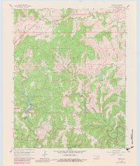
1960 Map of Herd
USGS Topo · Published 1983About this map
Caney River winds through the northern Osage landscape, anchoring a terrain defined by mid-century oil and gas development. This 1960 survey, updated with 1970s revisions, illustrates a working landscape where oil fields and numerous Oil Wells are interspersed among topographic landmarks like Twin Mounds and Horseshoe Bend. The settlement of Herd and the location of Bigheart are visible along the northern corridor, while a local Cem near Mission Creek offers a specific point of interest for genealogists tracing early families in this part of Osage County.
Find a feature on this map
26 named features on this map. Tap any name to fly to it.
Don’t see what you’re looking for? This feature index may not catch every label — zoom into the map to look around manually.
Map Details
Editions of this 1960 Herd Map
4 editions found
Other maps of this area

1906 · Nelagoney
USGS Topo · 1:24,000

1909 · Pawhuska
USGS Topo · 1:125,000

1910 · Pawhuska
USGS Topo · 1:125,000

1955 · Enid
USGS Topo · 1:250,000

1958 · Enid
USGS Topo · 1:250,000

1960 · Nanos
USGS Topo · 1:24,000

1960 · Nelagoney
USGS Topo · 1:24,000

1960 · Herd
USGS Topo · 1:24,000

1960 · Pawhuska
USGS Topo · 1:24,000
1971 · Bowring
USGS Topo · 1:24,000