
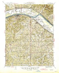
1945 Map of Hermann
USGS Topo · Published 1945About this map
The Missouri River cuts a wide path through this mid-1940s landscape, serving as the border for Montgomery, Gasconade, Warren, and Franklin counties. At the heart of the region, Hermann stands as a significant river and rail hub along the Missouri Pacific railroad, its topography defined by the drainage of Frene Creek and nearby Mc Girk Island. The rural interior is remarkably dense with community infrastructure, featuring an extensive network of schoolhouses like Frene Sch, Kaiser Hill Sch, and Upper Bottom Sch.
Find a feature on this map
74 named features on this map. Tap any name to fly to it.
Don’t see what you’re looking for? This feature index may not catch every label — zoom into the map to look around manually.
Map Details
Editions of this 1945 Hermann Map
2 editions found
Other maps of this area

1890 · Hermann
USGS Topo · 1:125,000

1890 · Fulton
USGS Topo · 1:125,000

1903 · Sullivan
USGS Topo · 1:125,000

1934 · Bland
USGS Topo · 1:62,500

1935 · Gerald
USGS Topo · 1:48,000

1935 · Morrison
USGS Topo · 1:48,000

1936 · Hermann
USGS Topo · 1:48,000

1937 · Bland
USGS Topo · 1:62,500

1940 · Montgomery City
USGS Topo · 1:62,500

1941 · Gerald
USGS Topo · 1:62,500