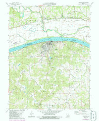
1974 Map of Hermann
USGS Topo · Published 1986About this map
Hermann serves as a focal point along the south bank of the Missouri River in this mid-1970s record, where the Missouri Pacific railroad tracks trace the shoreline below Kaltmeyers Bluff. Across the water, the floodplain is defined by Loutre River and Loutre Slough, while the northern bank carries the Missouri Kansas Texas line through McKittrick. The terrain south of the river is notably dotted with family-named burial sites, including the Langendoerfer Cem, Poeschel Cem, and Tinermeyer Cem, reflecting deep-rooted settlement patterns in Gasconade County. Industrial activity is evident in several Claypits and a Quarry near the city, while aviation and recreation are represented by the Hermann Muni Airport on Mc Girk Island and the Hermann Country Club to the north. This survey documents the area's transition between river-dependent industry and established agricultural communities.
Find a feature on this map
56 named features on this map. Tap any name to fly to it.
Don’t see what you’re looking for? This feature index may not catch every label — zoom into the map to look around manually.
Map Details
Editions of this 1974 Hermann Map
2 editions found
Other maps of this area

1890 · Hermann
USGS Topo · 1:125,000

1890 · Fulton
USGS Topo · 1:125,000

1935 · Morrison
USGS Topo · 1:48,000

1936 · Hermann
USGS Topo · 1:48,000

1940 · Montgomery City
USGS Topo · 1:62,500

1942 · Montgomery City
USGS Topo · 1:62,500

1942 · Morrison
USGS Topo · 1:62,500

1942 · Hermann
USGS Topo · 1:62,500

1942 · New Florence
USGS Topo · 1:62,500

1945 · Hermann
USGS Topo · 1:62,500