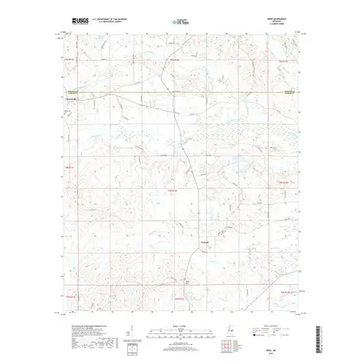
2018 Map of Hero
USGS Topo · Published 2018About this map
The boundary between Newton and Jasper counties divides this landscape of winding creek beds and rural crossroads. The settlement of Garlandville sits at the western edge of the map, anchored by the Garlandville Cemetery and a network of county roads like Gip Wall Road. Further south, the community of Penantly is situated near the banks of Penantly Creek, with the nearby Hopewell Cemetery serving as a significant landmark for genealogists. The terrain is defined by a dense network of waterways, including Scotchenflipper Creek, Souenlovie Creek, and North Twistwood Creek, which suggests a landscape historically shaped by drainage and small-scale agriculture. Smaller locales such as Moss Hill and the quadrangle's namesake, Hero, are connected by an intricate web of timber and farm roads, reflecting the region's enduring rural character.
Find a feature on this map
64 named features on this map. Tap any name to fly to it.
Don’t see what you’re looking for? This feature index may not catch every label — zoom into the map to look around manually.
Map Details
Editions of this 2018 Hero Map
This is the sole edition of this map. No revisions or reprints were ever made.
Other maps of this area

1953 · Meridian
USGS Topo · 1:250,000

1957 · Meridian
USGS Topo · 1:250,000

1957 · Chunky
USGS Topo · 1:62,500

1957 · Enterprise
USGS Topo · 1:62,500

1965 · Meridian
USGS Topo · 1:250,000

1966 · Hickory
USGS Topo · 1:24,000

1966 · Newton
USGS Topo · 1:24,000

1970 · Paulding
USGS Topo · 1:24,000

1970 · Hero
USGS Topo · 1:24,000
1970 · Montrose North
USGS Topo · 1:24,000