
1923 Map of Herscher
USGS Topo · Published 1959About this map
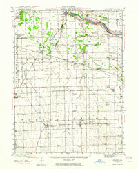
The Kankakee River defines the northern edge of this prairie landscape, where a dense network of early 20th-century railroads supported the region's agricultural and industrial output. The convergence of the Wabash, the Illinois Central, and the Cleveland Cincinnati Chicago and St Louis lines created critical transit points at settlements like Essex and Buckingham. Near Lehigh, the industrial footprint is marked by the Lehigh Stone Co Quarry, while the surrounding townships are dotted with dozens of namesake country schools. These institutions, such as Grey Craft School and Dublin School, reveal the once-populous rural school districts that served farming families before consolidation. Traceable rail sidings like Appel Siding and Dickey Siding illustrate the localized infrastructure required to move grain and stone from these small Illinois outposts to larger markets.
Find a feature on this map
75 named features on this map. Tap any name to fly to it.
Don’t see what you’re looking for? This feature index may not catch every label — zoom into the map to look around manually.
Map Details
Editions of this 1923 Herscher Map
2 editions found
Other maps of this area

1892 · Morris
USGS Topo · 1:62,500

1892 · Wilmington
USGS Topo · 1:62,500

1918 · Wilmington
USGS Topo · 1:62,500

1918 · Morris
USGS Topo · 1:62,500

1922 · Kankakee
USGS Topo · 1:62,500

1924 · Kankakee
USGS Topo · 1:62,500

1925 · Herscher
USGS Topo · 1:62,500

1944 · Piper City
USGS Topo · 1:48,000

1944 · Gilman
USGS Topo · 1:62,500

1946 · Gilman
USGS Topo · 1:62,500