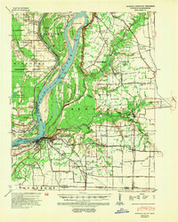
1939 Map of Hickman
USGS Topo · Published 1954About this map
The Mississippi River dominates this landscape, winding around Wolf Island No 5 and Wolf Island Bar as it transitions between Kentucky and Missouri. Along its banks, several river landings like Muscovalley Ldg and Dorena Ldg mark the riverine economy of the late 1930s. The town of Hickman sits atop a strategic bluff, overseeing the river's bend and a complex network of bayous and ponds, including Three Ponds and Little Eagle Pond.
Find a feature on this map
79 named features on this map. Tap any name to fly to it.
Don’t see what you’re looking for? This feature index may not catch every label — zoom into the map to look around manually.
Map Details
Editions of this 1939 Hickman Map
4 editions found
Other maps of this area

1925 · Reelfoot Lake
USGS Topo · 1:62,500

1939 · Wickliffe
USGS Topo · 1:62,500

1939 · Reelfoot Lake
USGS Topo · 1:62,500

1939 · Charleston
USGS Topo · 1:62,500

1939 · Hickman
USGS Topo · 1:62,500

1939 · Bayouville
USGS Topo · 1:62,500

1951 · Cayce
USGS Topo · 1:24,000

1951 · Bondurant
USGS Topo · 1:24,000

1951 · Oakton
USGS Topo · 1:24,000

1951 · Hickman
USGS Topo · 1:24,000