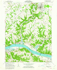
1961 Map of Higginsport
USGS Topo · Published 1963About this map
The Ohio River dominates this early 1960s survey, serving as the border between Brown County, Ohio and Bracken County, Kentucky. In Ohio, the riverfront village of Higginsport sits at the mouth of White Oak Creek, while Georgetown serves as the inland hub with its Fairgrounds, County Hospital, and the local Reed School. The Kentucky side features the established towns of Augusta and Dover, connected by the Chesapeake and Ohio railroad which follows the southern bank.
Find a feature on this map
71 named features on this map. Tap any name to fly to it.
Don’t see what you’re looking for? This feature index may not catch every label — zoom into the map to look around manually.
Map Details
Editions of this 1961 Higginsport Map
Other maps of this area

1915 · Maysville
USGS Topo · 1:62,500

1919 · Maysville
USGS Topo · 1:62,500

1928 · Higginsport
USGS Topo · 1:48,000

1931 · Felicity
USGS Topo · 1:62,500

1931 · Higginsport
USGS Topo · 1:62,500

1952 · Germantown
USGS Topo · 1:24,000

1952 · Higginsport
USGS Topo · 1:24,000

1952 · Maysville West
USGS Topo · 1:24,000

1952 · Brooksville
USGS Topo · 1:24,000

1953 · Bethel
USGS Topo · 1:24,000