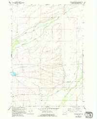
1966 Map of Highland Ranch
USGS Topo · Published 1994About this map
Swamp Creek and Moose Creek define the northern drainage of this Beaverhead County landscape, where the terrain transitions from seasonal wetlands into the foothills. The 1966 field data reveals a rural economy centered on cattle ranching and early-stage resource extraction, evidenced by the central Highland Ranch and multiple Gravel Pit locations scattered across the slopes. The southern portion of the map is dominated by the confluence of Rock Creek and Big Lake Creek, providing vital water sources for the remote homesteads. Genealogists will find the Briston Cem located near Briston Lane, a quiet marker of the early families who settled this high-altitude range. The survey captures a moment when traditional land use remained largely unchanged by modern development, preserving the original road alignments and water-rights infrastructure of the mid-20th century.
Find a feature on this map
14 named features on this map. Tap any name to fly to it.
Don’t see what you’re looking for? This feature index may not catch every label — zoom into the map to look around manually.
Map Details
Editions of this 1966 Highland Ranch Map
2 editions found
Other maps of this area

1955 · Dillon
USGS Topo · 1:250,000

1957 · Dillon
USGS Topo · 1:250,000

1958 · Dillon
USGS Topo · 1:250,000

1962 · Dillon
USGS Topo · 1:250,000

1962 · Wisdom
USGS Topo · 1:24,000

1962 · Mud Lake
USGS Topo · 1:24,000

1965 · Dillon
USGS Topo · 1:250,000

1966 · Gibbons School
USGS Topo · 1:24,000

1966 · Big Hole Battlefield
USGS Topo · 1:24,000

1966 · Jumbo Mountain
USGS Topo · 1:24,000