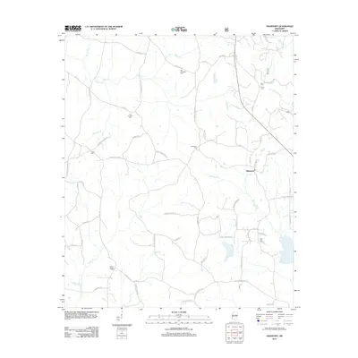
2012 Map of Highpoint
USGS Topo · Published 2012About this map
Highpoint sits as the central settlement in this rural Winston County landscape, defined by a dense network of country roads and creek drainages. The area is notable for its numerous burial grounds, which serve as vital landmarks for local family history and genealogy. Sites like Big Jerusalem Cem in the north and Owens Chapel Cem in the south are connected by a web of local routes, including Penderville Rd and McCool-Highpoint Rd.
Find a feature on this map
67 named features on this map. Tap any name to fly to it.
Don’t see what you’re looking for? This feature index may not catch every label — zoom into the map to look around manually.
Map Details
Editions of this 2012 Highpoint Map
This is the sole edition of this map. No revisions or reprints were ever made.
Other maps of this area

1953 · West Point
USGS Topo · 1:250,000

1958 · West Point
USGS Topo · 1:250,000

1963 · West Point
USGS Topo · 1:250,000

1966 · Weir
USGS Topo · 1:24,000

1968 · Weir
USGS Topo · 1:62,500

1972 · Louisville North
USGS Topo · 1:24,000

1972 · McCool
USGS Topo · 1:24,000

1972 · Highpoint
USGS Topo · 1:24,000
1972 · Ethel SE
USGS Topo · 1:24,000
1972 · Louisville South
USGS Topo · 1:24,000