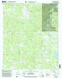
2000 Map of Highpoint
USGS Topo · Published 2002About this map
Tombigbee National Forest dominates the northeast quadrant of this landscape, where the Noxubee River begins its course through a heavily wooded terrain. Situated along the boundary of Choctaw and Winston Counties, the map documents a rural community defined by a high density of country churches and family burial grounds. The namesake settlement of Highpoint sits near the eastern edge, serving as a focal point for a network of secondary roads that connect numerous spiritual centers including Big Jerusalem Church, Sister Jerusalem Church, and Bethsalem Ch. This concentration of religious sites, often paired with cemeteries like Old Concord Cem or Turner Cem, provides a detailed record of the social and ancestral geography for this part of Mississippi. Drainage patterns are well-defined by numerous waterways such as Tibby Creek, Lobutcha Creek, and Tallahaga Creek, which carve through the timberlands and fields surrounding Owens Chapel and New Zion Ch.
Find a feature on this map
26 named features on this map. Tap any name to fly to it.
Don’t see what you’re looking for? This feature index may not catch every label — zoom into the map to look around manually.
Map Details
Editions of this 2000 Highpoint Map
This is the sole edition of this map. No revisions or reprints were ever made.
Other maps of this area

1953 · West Point
USGS Topo · 1:250,000

1958 · West Point
USGS Topo · 1:250,000

1963 · West Point
USGS Topo · 1:250,000

1966 · Weir
USGS Topo · 1:24,000

1968 · Weir
USGS Topo · 1:62,500

1972 · Louisville North
USGS Topo · 1:24,000

1972 · McCool
USGS Topo · 1:24,000

1972 · Highpoint
USGS Topo · 1:24,000
1972 · Ethel SE
USGS Topo · 1:24,000
1972 · Louisville South
USGS Topo · 1:24,000