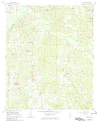
1967 Map of Hightogy
USGS Topo · Published 1982About this map
Vernon serves as a primary hub in this portion of Lamar County, where the landscape is defined by the winding paths of Yellow Creek and Hells Creek. The map documents a rural network of community centers anchored by local congregations, such as Bethel Ch and South Carolina Ch, and the small settlements of Hightogy and Kingville. This 1967 survey, updated with 1981 photogrammetric data, reveals a transition in land use through the prevalence of Gravel Pit sites scattered across the ridges. These excavations, alongside the Substation and a local Roadside Park, highlight the rural industrial and infrastructure development of the mid-to-late 20th century. For genealogists, the map is a detailed record of local family history, noting several cemeteries and smaller churches like Meadow Branch Ch and Christian Chapel.
Find a feature on this map
29 named features on this map. Tap any name to fly to it.
Don’t see what you’re looking for? This feature index may not catch every label — zoom into the map to look around manually.
Map Details
Editions of this 1967 Hightogy Map
3 editions found
Other maps of this area

1953 · Birmingham
USGS Topo · 1:250,000

1953 · West Point
USGS Topo · 1:250,000

1956 · Birmingham
USGS Topo · 1:250,000

1957 · Birmingham
USGS Topo · 1:250,000

1958 · West Point
USGS Topo · 1:250,000

1963 · West Point
USGS Topo · 1:250,000

1967 · Hightogy
USGS Topo · 1:24,000

1967 · Kennedy
USGS Topo · 1:24,000

1967 · Bluff
USGS Topo · 1:24,000

1967 · Millport
USGS Topo · 1:24,000