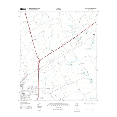
2012 Map of Hillsboro East
USGS Topo · Published 2012About this map
The city of Hillsboro anchor the southwest corner of this study, showcasing its development near the Hill Coll campus and the historic Ridge Cem. The landscape transitions from urban grid patterns to a dense network of agricultural water management systems, notably featuring a series of Soil Conservation Service reservoirs along White Rock Cr and Pecan Cr. Transport and commerce define the corridor between Hillsboro and Carls Corner, marked by the Hillsboro Municipal Airport and the Prime Outlets at Hillsboro. Smaller settlements like Midway and Mountain View appear near the northern and eastern margins, while the presence of Iseriberg Lake and Katy Lake highlights the local reliance on managed water bodies for the surrounding ranching and farming operations in this part of Hill County.
Find a feature on this map
113 named features on this map. Tap any name to fly to it.
Don’t see what you’re looking for? This feature index may not catch every label — zoom into the map to look around manually.
Map Details
Editions of this 2012 Hillsboro East Map
This is the sole edition of this map. No revisions or reprints were ever made.
Other maps of this area

1891 · Cleburne
USGS Topo · 1:125,000

1892 · Waco
USGS Topo · 1:125,000

1894 · Cleburne
USGS Topo · 1:125,000

1920 · Waco
USGS Topo · 1:125,000

1954 · Dallas
USGS Topo · 1:250,000

1954 · Waco
USGS Topo · 1:250,000

1955 · Waco
USGS Topo · 1:250,000

1956 · Abbott
USGS Topo · 1:24,000
1957 · Peoria
USGS Topo · 1:24,000
1957 · Malone
USGS Topo · 1:24,000