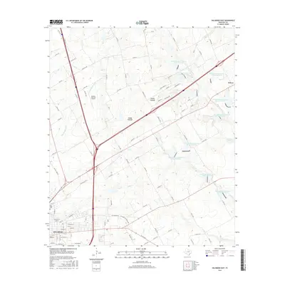
2016 Map of Hillsboro East
USGS Topo · Published 2016About this map
The city of Hillsboro occupies the southwestern portion of this Hill County survey, showcasing the modern infrastructure of this regional hub. Educational and civic landmarks like Hill Coll and the Park Ridge Cem stand alongside the grid of city streets, while the Hillsboro Municipal Airport serves as a transportation anchor to the north. The surrounding landscape is defined by a dense network of water management features, notably a series of Soil Conservation Service reservoirs such as Site 52 and Site 61 that dot the drainages of Pecan Cr and White Rock Cr. To the northeast, the small community of Carl's Corner sits at the intersection of major thoroughfares, illustrating the transition from the concentrated urban center of Hillsboro to the agricultural expanses and ranch lands of North Central Texas.
Find a feature on this map
106 named features on this map. Tap any name to fly to it.
Don’t see what you’re looking for? This feature index may not catch every label — zoom into the map to look around manually.
Map Details
Editions of this 2016 Hillsboro East Map
This is the sole edition of this map. No revisions or reprints were ever made.
Other maps of this area

1891 · Cleburne
USGS Topo · 1:125,000

1892 · Waco
USGS Topo · 1:125,000

1894 · Cleburne
USGS Topo · 1:125,000

1920 · Waco
USGS Topo · 1:125,000

1954 · Dallas
USGS Topo · 1:250,000

1954 · Waco
USGS Topo · 1:250,000

1955 · Waco
USGS Topo · 1:250,000

1956 · Abbott
USGS Topo · 1:24,000
1957 · Peoria
USGS Topo · 1:24,000
1957 · Malone
USGS Topo · 1:24,000