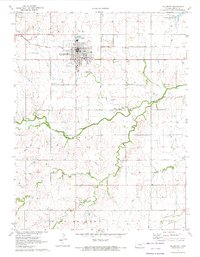
1971 Map of Hillsboro
USGS Topo · Published 1973About this map
The town of Hillsboro serves as the focal point of this Marion County study, showing the community just as the Marion Reservoir altered the northern landscape. The presence of numerous specialized cemeteries, such as the historic Gnadenau Cem and Zion Cem, reflects the deep Mennonite and German heritage of the area. Industrial and civic growth is evident through the Hillsboro Municipal Airport, a dedicated Fairground, and an emerging Industrial Site near the Atchison Topeka and Santa Fe railroad tracks. Moving south from the town center, the terrain is defined by the winding course of the South Cottonwood River and Antelope Creek, where local landmarks like the Ebenfeld School and Gard Cem anchor the rural landscape. The grid-like organization of townships including Risley, Liberty, and Wilson illustrates the systematic agricultural development characteristic of the Kansas plains in the early 1970s.
Find a feature on this map
30 named features on this map. Tap any name to fly to it.
Don’t see what you’re looking for? This feature index may not catch every label — zoom into the map to look around manually.
Map Details
Editions of this 1971 Hillsboro Map
2 editions found
Other maps of this area

1889 · Newton
USGS Topo · 1:125,000

1894 · Newton
USGS Topo · 1:125,000

1955 · Hutchinson
USGS Topo · 1:250,000

1957 · Peabody NW
USGS Topo · 1:24,000

1957 · Peabody
USGS Topo · 1:24,000

1959 · Hutchinson
USGS Topo · 1:250,000

1965 · Goessel
USGS Topo · 1:24,000

1971 · Durham
USGS Topo · 1:24,000
1971 · Lehigh
USGS Topo · 1:24,000
1971 · Waldeck
USGS Topo · 1:24,000