1927 Map of Hinsdale
USGS Topo · Published 1927About this map
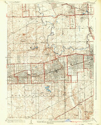
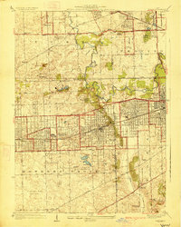
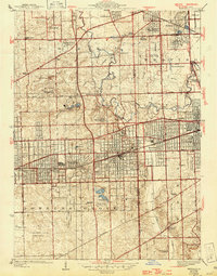
Hinsdale and its neighboring villages are captured here during a period of rapid suburban maturation along the rail corridors of the Chicago Burlington and Quincy Railroad. The map reveals a transition from open farmland to organized grid layouts in Western Springs, Westmont, and Clarendon Hills. The landscape is notably dotted with prominent institutions and recreational grounds, including the St Joseph Institute and the Hinsdale Golf Club. In the northern portion of the survey, the Illinois Central Railroad and Chicago Aurora and Elgin Electric lines serve established communities like Villa Park and Bellwood. Large tracts of land are dedicated to massive cemetery complexes such as Mt Carmel Cemetery and Glen Oak Cemetery. The meandering path of Salt Creek and the southern Flag Creek provide the primary natural drainage amidst a burgeoning network of thoroughfares like Roosevelt Road and the Joliet State Highway.
Find a feature on this map
63 named features on this map. Tap any name to fly to it.
Don’t see what you’re looking for? This feature index may not catch every label — zoom into the map to look around manually.
Map Details
Editions of this 1927 Hinsdale Map
3 editions found
Other maps of this area

1890 · Des Plaines
USGS Topo · 1:62,500

1891 · Riverside
USGS Topo · 1:62,500

1892 · Joliet
USGS Topo · 1:62,500

1893 · Riverside
USGS Topo · 1:62,500

1894 · Des Plaines
USGS Topo · 1:62,500

1900 · Des Plaines
USGS Topo · 1:62,500

1900 · Riverside
USGS Topo · 1:62,500

1901 · Des Plaines
USGS Topo · 1:62,500

1901 · Riverside
USGS Topo · 1:62,500

1908 · Wheaton
USGS Topo · 1:62,500