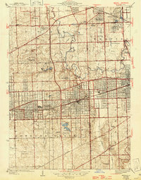
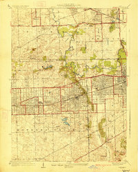
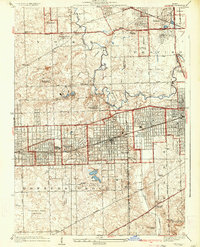
1927 Map of Hinsdale
USGS Topo · Published 1946About this map
Salt Creek meanders through this landscape, marking the transition from the established settlements of Hinsdale and Western Springs to the rolling terrain further west. The survey reveals a region in the midst of suburban expansion, where extensive estates and private clubs like the Butterfield Country Club and Ruth Lake Country Club occupy large tracts between growing residential blocks. The Indian Boundary line cuts diagonally across the center, a historical surveyor's mark that still influenced land division in this era.
Find a feature on this map
70 named features on this map. Tap any name to fly to it.
Don’t see what you’re looking for? This feature index may not catch every label — zoom into the map to look around manually.
Map Details
Editions of this 1927 Hinsdale Map
3 editions found
Other maps of this area

1890 · Des Plaines
USGS Topo · 1:62,500

1891 · Riverside
USGS Topo · 1:62,500

1892 · Joliet
USGS Topo · 1:62,500

1893 · Riverside
USGS Topo · 1:62,500

1894 · Des Plaines
USGS Topo · 1:62,500

1900 · Des Plaines
USGS Topo · 1:62,500

1900 · Riverside
USGS Topo · 1:62,500

1901 · Des Plaines
USGS Topo · 1:62,500

1901 · Riverside
USGS Topo · 1:62,500

1908 · Wheaton
USGS Topo · 1:62,500