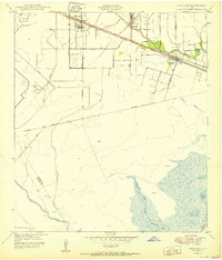
1950 Map of Hitchcock
USGS Topo · Published 1950About this map
The Atchison Topeka and Santa Fe railroad serves as the primary corridor for settlement in this coastal Texas landscape, linking the communities of Alta Loma and Hitchcock. To the north, the Camp Wallace Military Reservation occupies a significant portion of the terrain, while the southern reaches of the map dissolve into the marshy wetlands of Karankawa Lake and Greens Lake. Genealogists will find notable detail in the multiple burial grounds, including the Alta Loma Cemetery and Galveston Memorial Cemetery. The landscape is defined by an intricate network of drainage, where Highland Bayou and Halls Bayou wind through the flat coastal plain toward the Intracoastal Waterway. Rural infrastructure is marked by numerous family-named roads such as Tacquard Road and McElmoyle Road, alongside scattered windmills and early oil tanks.
Find a feature on this map
28 named features on this map. Tap any name to fly to it.
Don’t see what you’re looking for? This feature index may not catch every label — zoom into the map to look around manually.
Map Details
Editions of this 1950 Hitchcock Map
This is the sole edition of this map. No revisions or reprints were ever made.
Other maps of this area

1929 · Dickinson
USGS Topo · 1:24,000

1929 · Karankawa Lake
USGS Topo · 1:24,000

1929 · Algoa
USGS Topo · 1:24,000

1929 · Hitchcock
USGS Topo · 1:24,000

1929 · Virginia Point
USGS Topo · 1:24,000

1929 · Texas City
USGS Topo · 1:24,000

1931 · Lake Como
USGS Topo · 1:24,000

1932 · Algoa
USGS Topo · 1:31,680

1932 · Dickinson
USGS Topo · 1:31,680

1932 · Texas City
USGS Topo · 1:31,680