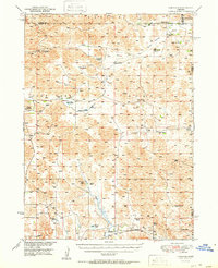
1951 Map of Hoagland
USGS Topo · Published 1951About this map
The North Fork Loup River valley defines this mid-century portrait of Logan County, where the southern portion of the map centers on the small settlement of Hoagland along the Union Pacific railroad line. The landscape reflects a ranching economy, documented through numerous family-named homesteads including the McGooden Ranch, Johnson Ranch, and Halstead Ranch. These ranching operations are interspersed among unique hydrographic features like Wild Horse Flats and isolated bodies of water such as Mudd Lake and Philpott Lake.
Find a feature on this map
36 named features on this map. Tap any name to fly to it.
Don’t see what you’re looking for? This feature index may not catch every label — zoom into the map to look around manually.
Map Details
Editions of this 1951 Hoagland Map
2 editions found

Other maps of this area

1899 · North Platte
USGS Topo · 1:125,000

1902 · North Platte
USGS Topo · 1:125,000

1948 · Thedford
USGS Topo · 1:62,500

1948 · Linscott
USGS Topo · 1:62,500

1948 · Halsey
USGS Topo · 1:62,500

1949 · Cody Lake
USGS Topo · 1:62,500

1950 · Linscott
USGS Topo · 1:62,500

1950 · Thedford
USGS Topo · 1:62,500

1950 · Halsey
USGS Topo · 1:62,500

1951 · Dunning
USGS Topo · 1:62,500