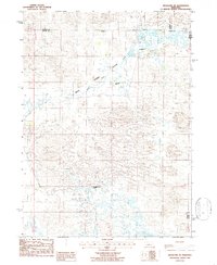
1986 Map of Hoagland NE
USGS Topo · Published 1986About this map
Wild Horse Flats dominates the center of this Nebraska landscape, where the wide, sandy terrain of the Sandhills is punctuated by a network of isolated homesteads. The cattle ranching economy of the mid-1980s is clearly visible through family-named operations like Rau Ranch, Collier Ranch, and Schmidt Ranch situated along the drainage of Horse Creek. In the southern portion of the quadrangle, the terrain transitions toward the drainage basin of Wild Horse Creek, where the Wild Horse Creek Ranch is located. This survey provides a precise record of the land use patterns and rural infrastructure in the tri-county area of Logan, Thomas, and Blaine counties before modern consolidation altered many of these historic ranching boundaries.
Find a feature on this map
12 named features on this map. Tap any name to fly to it.
Don’t see what you’re looking for? This feature index may not catch every label — zoom into the map to look around manually.
Map Details
Editions of this 1986 Hoagland NE Map
This is the sole edition of this map. No revisions or reprints were ever made.
Other maps of this area

1948 · Linscott
USGS Topo · 1:62,500

1948 · Halsey
USGS Topo · 1:62,500

1950 · Linscott
USGS Topo · 1:62,500

1950 · Halsey
USGS Topo · 1:62,500

1951 · Dunning
USGS Topo · 1:62,500

1951 · Hoagland
USGS Topo · 1:62,500

1954 · North Platte
USGS Topo · 1:250,000

1956 · North Platte
USGS Topo · 1:250,000

1957 · North Platte
USGS Topo · 1:250,000

1967 · North Platte
USGS Topo · 1:250,000