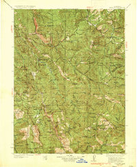
1935 Map of Hoaglin
USGS Topo · Published 1935About this map
Trinity National Forest and Mendocino National Forest meet in this mid-1930s landscape of high peaks and isolated homesteads. The terrain is deeply cut by the South Fork Trinity River and the Mad River, creating a remote topography where small-scale ranching and mining define the human presence. Pockets of settlement are concentrated in rare level ground like Hoaglin Valley and Kettenpom Valley, supported by a network of rural schoolhouses including Kettenpom Pk Sch and Lake Mtn Sch.
Find a feature on this map
141 named features on this map. Tap any name to fly to it.
Don’t see what you’re looking for? This feature index may not catch every label — zoom into the map to look around manually.
Map Details
Editions of this 1935 Hoaglin Map
3 editions found

Other maps of this area

1890 · Red Bluff
USGS Topo · 1:250,000

1894 · Red Bluff
USGS Topo · 1:250,000

1909 · Big Bar
USGS Topo · 1:96,000

1913 · Weaverville
USGS Topo · 1:125,000

1914 · Pilot Creek
USGS Topo · 1:62,500

1915 · Big Bar and Vicinity
USGS Topo · 1:250,000

1918 · Anada
USGS Topo · 1:62,500

1920 · Cummings
USGS Topo · 1:62,500

1920 · Covelo
USGS Topo · 1:62,500

1920 · Harris
USGS Topo · 1:62,500