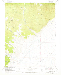
1968 Map of Hobble Canyon
USGS Topo · Published 1973About this map
Hot Creek Ranch and Upper Hot Creek Ranch anchor the southern reach of the Hot Creek Valley, where the desert floor meets the steep drainages of the surrounding range. This late-1960s landscape is defined by its water sources and historical resource extraction, evidenced by several Kiln sites positioned near the mouths of Charcoal Canyon and South Sixmile Canyon. These kilns point to earlier timber and fuel processing required for regional mining operations.
Find a feature on this map
21 named features on this map. Tap any name to fly to it.
Don’t see what you’re looking for? This feature index may not catch every label — zoom into the map to look around manually.
Map Details
Editions of this 1968 Hobble Canyon Map
2 editions found
Other maps of this area

1956 · Tonopah
USGS Topo · 1:250,000

1959 · Tonopah
USGS Topo · 1:250,000

1962 · Tonopah
USGS Topo · 1:250,000

1967 · Lunar Crater
USGS Topo · 1:62,500

1967 · Moores Station
USGS Topo · 1:62,500

1967 · Blue Jay Spring
USGS Topo · 1:24,000

1967 · Upper Fish Lake
USGS Topo · 1:24,000

1967 · Palisade Mesa
USGS Topo · 1:24,000

1967 · Moores Station
USGS Topo · 1:24,000

1967 · Morey Peak
USGS Topo · 1:24,000