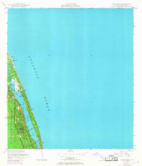
1948 Map of Hobe Sound
USGS Topo · Published 1968About this map
Jonathan Dickinson State Park dominates the western landscape of this coastal survey, where the lush Florida scrub meets the winding Intracoastal Waterway. The geography is defined by narrow barrier strips and protected waters like the Jupiter Narrows and Hobe Sound, providing a look at the area before modern sprawling development. Local landmarks such as the Jupiter Island Country Club and the US Coast Guard Station near Bonair Beach highlight the region's mid-century identity as a blend of maritime security and seasonal recreation. Of particular interest to genealogists and local historians are the numerous lettered markers like Simpson Hill (C), Borden Hill (C), and Hild (C), which indicate specific control points or residential developments along the shoreline. The transition from the dense woodlands of the state park to the manicured Golf Course on the barrier island illustrates the emerging land-use patterns of the late 1940s and 1960s.
Find a feature on this map
24 named features on this map. Tap any name to fly to it.
Don’t see what you’re looking for? This feature index may not catch every label — zoom into the map to look around manually.
Map Details
Editions of this 1948 Hobe Sound Map
4 editions found
Other maps of this area

1948 · Rood
USGS Topo · 1:24,000

1948 · St. Lucie Inlet
USGS Topo · 1:24,000

1948 · Gomez
USGS Topo · 1:24,000

1948 · Hobe Sound
USGS Topo · 1:24,000

1948 · Jupiter
USGS Topo · 1:24,000

1949 · Rood
USGS Topo · 1:24,000

1949 · Gomez
USGS Topo · 1:24,000

1949 · Hobe Sound
USGS Topo · 1:24,000

1950 · St. Lucie Inlet
USGS Topo · 1:24,000

1950 · Jupiter
USGS Topo · 1:24,000