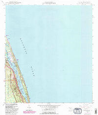
1948 Map of Hobe Sound
USGS Topo · Published 1983About this map
Jupiter Island and the adjacent barrier beach landscape are captured here during a period of transition in the 1940s, with updates reflecting the early 1980s environment. The map shows the coastal corridor defined by the Florida East Coast railway and the Intracostal Waterway, which separates the mainland from the exclusive enclave of the Jupiter Island Country Club. Large protected areas like Jonathan Dickinson State Park and the Hobe Sound National Wildlife Refuge dominate the western and central portions of the sheet, preserving the native Florida scrub and wetlands. Settlement patterns are concentrated along the coast and rail line, including the Hobe Sound station and smaller residential pockets like Bonair Beach. The presence of several named high points, such as Borden Hill and Simpson Hill, suggests a unique coastal topography often overlooked in flatter parts of the state.
Find a feature on this map
28 named features on this map. Tap any name to fly to it.
Don’t see what you’re looking for? This feature index may not catch every label — zoom into the map to look around manually.
Map Details
Editions of this 1948 Hobe Sound Map
4 editions found
Other maps of this area

1948 · Rood
USGS Topo · 1:24,000

1948 · St. Lucie Inlet
USGS Topo · 1:24,000

1948 · Gomez
USGS Topo · 1:24,000

1948 · Hobe Sound
USGS Topo · 1:24,000

1948 · Jupiter
USGS Topo · 1:24,000

1949 · Rood
USGS Topo · 1:24,000

1949 · Gomez
USGS Topo · 1:24,000

1949 · Hobe Sound
USGS Topo · 1:24,000

1950 · St. Lucie Inlet
USGS Topo · 1:24,000

1950 · Jupiter
USGS Topo · 1:24,000