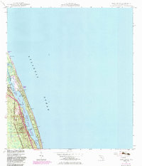
1948 Map of Hobe Sound
USGS Topo · Published 1983About this map
Jupiter Island and the adjacent Florida coastline appear here in a period of transition, documented through topographic surveys from 1947–1948 and photorevised in the early 1980s. This survey illustrates the ribbon of development along the Intracoastal Waterway, where the Jupiter Island Country Club and the Hobe Sound post office serve as local anchors. The landscape is defined by its barrier island geography and protected lands, including the expansive Jonathan Dickinson State Park and the Hobe Sound N W R. Notable local elevations like Simpson Hill (C) and Borden Hill (C) provide geographic context for the coastal ridge, while small shoreline settlements such as Bonair Beach dot the Atlantic side. The map also identifies infrastructure like a submarine Cable Area and Pipe Line, reflecting the utilities supporting this growing coastal community.
Find a feature on this map
29 named features on this map. Tap any name to fly to it.
Don’t see what you’re looking for? This feature index may not catch every label — zoom into the map to look around manually.
Map Details
Editions of this 1948 Hobe Sound Map
4 editions found
Other maps of this area

1948 · Rood
USGS Topo · 1:24,000

1948 · St. Lucie Inlet
USGS Topo · 1:24,000

1948 · Gomez
USGS Topo · 1:24,000

1948 · Hobe Sound
USGS Topo · 1:24,000

1948 · Jupiter
USGS Topo · 1:24,000

1949 · Rood
USGS Topo · 1:24,000

1949 · Gomez
USGS Topo · 1:24,000

1949 · Hobe Sound
USGS Topo · 1:24,000

1950 · St. Lucie Inlet
USGS Topo · 1:24,000

1950 · Jupiter
USGS Topo · 1:24,000