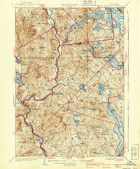
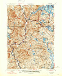
1927 Map of Holderness
USGS Topo · Published 1940About this map
The Pemigewasset River and the Boston and Maine RR define the north-south transit corridor through the heart of this region during the mid-1920s. This survey, compiled in part from early aerial photography, reveals a landscape densely dotted with rural infrastructure, including a remarkable number of small school districts such as Plaisted School, Hannaford School, and River Road School. The settlement pattern centers on towns like Ashland and Bristol, while the eastern portion of the sheet is dominated by the sprawling waters of Squam Lake and the western edge of Lake Winnipesaukee. The topography is defined by significant elevations like Hersey Mtn and Leavitt Mtn, which separate the river valleys from the lake basins. Local spiritual life is anchored by landmarks like Dana Church and the Bay Meeting House, providing specific points of interest for genealogists tracing family roots in Belknap and Grafton counties.
Find a feature on this map
90 named features on this map. Tap any name to fly to it.
Don’t see what you’re looking for? This feature index may not catch every label — zoom into the map to look around manually.
Map Details
Editions of this 1927 Holderness Map
6 editions found
Other maps of this area

1909 · Winnepesaukee
USGS Topo · 1:62,500

1919 · Gilmanton
USGS Topo · 1:62,500

1925 · Holderness
USGS Topo · 1:62,500

1927 · Penacook
USGS Topo · 1:62,500

1927 · Gilmanton
USGS Topo · 1:62,500

1927 · Holderness
USGS Topo · 1:62,500

1927 · Cardigan
USGS Topo · 1:62,500

1928 · Mount Kearsarge
USGS Topo · 1:62,500

1928 · Plymouth
USGS Topo · 1:62,500

1928 · Rumney
USGS Topo · 1:62,500