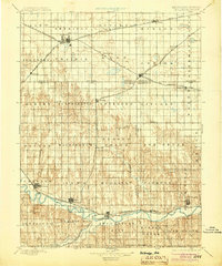
1896 Map of Holdrege
USGS Topo · Published 1904About this map
The Burlington and Missouri River R. R. network anchors this late-19th-century landscape, branching across the plains to connect growing agricultural centers like Holdrege and Orleans. The southern portion of the survey is defined by the winding course of the Republican River, where early settlements such as Alma, Naponee, and Bloomington sit near the confluence of Turkey Creek and Prairie Dog Creek.
Find a feature on this map
65 named features on this map. Tap any name to fly to it.
Don’t see what you’re looking for? This feature index may not catch every label — zoom into the map to look around manually.
Map Details
Editions of this 1896 Holdrege Map
5 editions found
Other maps of this area

1893 · Smith Center
USGS Topo · 1:125,000

1893 · Norton
USGS Topo · 1:125,000

1893 · Phillipsburg
USGS Topo · 1:125,000

1894 · Kearney
USGS Topo · 1:62,500

1894 · Minden
USGS Topo · 1:62,500

1896 · Lexington
USGS Topo · 1:125,000

1896 · Holdrege
USGS Topo · 1:125,000

1896 · Kearney
USGS Topo · 1:125,000

1896 · Arapahoe
USGS Topo · 1:125,000

1896 · Wood River
USGS Topo · 1:125,000