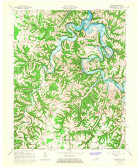
1965 Map of Holland
USGS Topo · Published 1967About this map
The Barren River Reservoir dominates this mid-1960s landscape, with its waters reaching a normal pool elevation of 552 feet as mapped by the U.S. Corps of Engineers. The meandering path of the Barren River creates dramatic terrain features such as Horseshoe Bend and Jewsharp Bend, while the surrounding hills are dotted with small rural communities and civic foundations. Settlements like Holland, Mt Zion, and Amos serve as anchors for the local population, supported by a network of spiritual and educational landmarks including Mt Zion Church and the nearby Mt Zion School. This survey captures the region just as the reservoir's controlled inundation transformed the local geography, particularly around the confluence of Rhodes Creek and Boulany Creek, marking a significant shift in the area's hydraulic and social character near the Kentucky-Tennessee border.
Find a feature on this map
40 named features on this map. Tap any name to fly to it.
Don’t see what you’re looking for? This feature index may not catch every label — zoom into the map to look around manually.
Map Details
Editions of this 1965 Holland Map
This is the sole edition of this map. No revisions or reprints were ever made.
Other maps of this area

1926 · Scottsville
USGS Topo · 1:62,500

1931 · Lafayette
USGS Topo · 1:62,500

1931 · Red Boiling Springs
USGS Topo · 1:62,500

1953 · Tracy
USGS Topo · 1:24,000

1954 · Austin
USGS Topo · 1:24,000

1954 · Fountain Run
USGS Topo · 1:24,000

1954 · Petroleum
USGS Topo · 1:24,000

1954 · Scottsville
USGS Topo · 1:24,000

1954 · Holland
USGS Topo · 1:24,000

1956 · Corbin
USGS Topo · 1:250,000