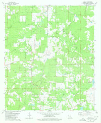
1980 Map of Holly
USGS Topo · Published 1980About this map
The Kansas City Southern railroad serves as the primary corridor through this section of De Soto Parish, connecting the community of Frierson in the north to Kingston and Holly further south. The landscape is characterized by a dense network of bayous, including Brushy Bayou, Sand Bayou, and Rambin Bayou, which drain the low-lying terrain. Significant local heritage is evident at the Lands End Plantation near the headwaters of Sylvest Creek, while several rural houses of worship such as Mt Moriah Ch and St Rest Ch anchor the scattered settlements. The mid-20th-century economic footprint of the region is clearly marked by the Holly Gas and Oil Field, which is interlaced with pipelines and drilling infrastructure. Near the eastern edge, the Clear Lake Spillway regulates local water levels, while landmarks like Kingston Station highlight the historical importance of the rail line to these rural Louisiana communities.
Find a feature on this map
42 named features on this map. Tap any name to fly to it.
Don’t see what you’re looking for? This feature index may not catch every label — zoom into the map to look around manually.
Map Details
Editions of this 1980 Holly Map
2 editions found
Other maps of this area

1945 · Grand Cane
USGS Topo · 1:62,500

1945 · Greenwood
USGS Topo · 1:62,500

1945 · Mansfield
USGS Topo · 1:62,500

1947 · Mansfield
USGS Topo · 1:62,500

1948 · Caspiana
USGS Topo · 1:62,500

1955 · Shreveport
USGS Topo · 1:250,000

1955 · Caspiana
USGS Topo · 1:62,500

1955 · Greenwood
USGS Topo · 1:62,500

1956 · Shreveport
USGS Topo · 1:250,000
1957 · Grand Cane
USGS Topo · 1:62,500