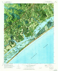
1970 Map of Holly Ridge
USGS Topo · Published 1973About this map
The dense forests of the Holly Shelter State Wildlife Management Area dominate the inland landscape of Onslow and Pender counties, contrasting sharply with the burgeoning coastal developments along the Atlantic Ocean. This orthophotomap, produced from 1969 aerial photography, reveals the intricate network of water and land that defines the region. The Intracoastal Waterway cuts a straight line through the backwaters, separating the mainland from barrier island communities like Surf City and Topsail Beach.
Find a feature on this map
29 named features on this map. Tap any name to fly to it.
Don’t see what you’re looking for? This feature index may not catch every label — zoom into the map to look around manually.
Map Details
Editions of this 1970 Holly Ridge Map
This is the sole edition of this map. No revisions or reprints were ever made.
Other maps of this area

1942 · Spicer Bay
USGS Topo · 1:62,500

1942 · Topsail
USGS Topo · 1:62,500

1948 · Maple Hill
USGS Topo · 1:62,500

1948 · Topsail
USGS Topo · 1:62,500

1948 · New River
USGS Topo · 1:62,500

1952 · Spicer Bay
USGS Topo · 1:24,000

1952 · Sneads Ferry
USGS Topo · 1:24,000

1953 · Beaufort
USGS Topo · 1:250,000

1954 · Beaufort
USGS Topo · 1:250,000

1970 · Hampstead
USGS Topo · 1:24,000
Featured Places
- Surf City, NC
- Holly Ridge, NC
- North Topsail Beach, NC
- Topsail Beach, NC
- Marine Corps Base Camp Lejeune, NC