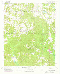
1964 Map of Holly Springs SE
USGS Topo · Published 1976About this map
Holly Springs National Forest dominates the landscape of northern Mississippi in this mid-1960s study, revealing a rural expanse defined by its ridges and watercourses. The Illinois Central Gulf railroad cuts through the northwestern corner near the settlement of Hudsonville, while the Coldwater River and its various tributaries like Chewalla Creek and Little Snow Creek carve out the topography. This period shows a transition in the local infrastructure, with several pipelines traversing the forest terrain and a clear distinction between the established church-and-cemetery centers of the community and the developing recreational features like Snow Lake. Genealogists will find a high density of rural burial grounds, including Mitchell Cem, Chestnut Grove Cem, and Shawnee Cem, which serve as markers for family homesteads scattered throughout the wooded hills and creek bottoms.
Find a feature on this map
31 named features on this map. Tap any name to fly to it.
Don’t see what you’re looking for? This feature index may not catch every label — zoom into the map to look around manually.
Map Details
Editions of this 1964 Holly Springs SE Map
2 editions found
Other maps of this area

1944 · Potts Camp
USGS Topo · 1:62,500

1945 · Potts Camp
USGS Topo · 1:62,500

1950 · Ashland
USGS Topo · 1:62,500

1953 · Holly Springs
USGS Topo · 1:62,500

1955 · Blue Mountain
USGS Topo · 1:62,500

1956 · Tupelo
USGS Topo · 1:250,000

1958 · Tupelo
USGS Topo · 1:250,000

1964 · Waterford
USGS Topo · 1:24,000

1964 · Holly Springs SE
USGS Topo · 1:24,000
1965 · Slayden
USGS Topo · 1:24,000