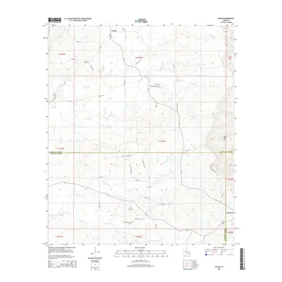
2015 Map of Holum
USGS Topo · Published 2015About this map
Holum and the nearby Rosefield settlement occupy the rolling elevations of North-Central Louisiana, where the border of Caldwell Parish meets LaSalle Parish and Catahoula Parish. This landscape is defined by its intricate drainage systems, including Chickasaw Cr, Black Bayou, and the curiously named Bayou Funny Louis. The terrain rises notably at the Bayou Dan Hills in the southeast, contrasting with the lower creek bottoms. Genealogy researchers will find several local landmarks of interest, including the Little Star Cem and Pine Grove Cem, alongside roads named for established local families such as Joyner Rd, Volentine Rd, and Claunch Rd. The presence of several industrial park roads, such as Industrial Park 44, indicates modern economic activity amidst the traditional rural landscape of pine forests and winding waterways.
Find a feature on this map
58 named features on this map. Tap any name to fly to it.
Don’t see what you’re looking for? This feature index may not catch every label — zoom into the map to look around manually.
Map Details
Editions of this 2015 Holum Map
This is the sole edition of this map. No revisions or reprints were ever made.
Other maps of this area
1939 · Fort Necessity
USGS Topo · 1:62,500
1940 · Columbia
USGS Topo · 1:62,500
1941 · Harrisonburg
USGS Topo · 1:62,500

1953 · Alexandria
USGS Topo · 1:250,000
1953 · Natchez
USGS Topo · 1:250,000

1955 · Jackson
USGS Topo · 1:250,000
1955 · Shreveport
USGS Topo · 1:250,000

1955 · Alexandria
USGS Topo · 1:250,000
1955 · Olla
USGS Topo · 1:62,500
1956 · Shreveport
USGS Topo · 1:250,000