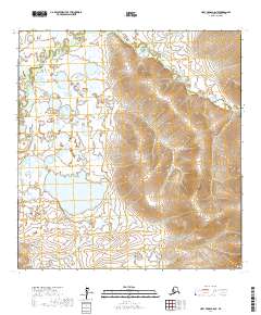
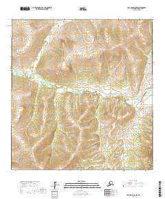
2017 Map of Holy Cross A-6 NE
USGS Topo · Published 2017About this map
Nageethluk River winds through the northern reaches of this remote Alaskan landscape, where the terrain transitions from expansive, low-lying wetlands to significant upland relief. The topography is dominated by a major hillside that rises steeply across the eastern half of the survey, contrasting with the dense network of small ponds and saturated flats to the west. This area within the Kusilvak Census Area remains largely defined by its natural hydrology and raw elevation rather than permanent infrastructure. The map provides a clear look at the intricate drainage patterns feeding into the Nageethluk River and the precise boundaries of public land divisions, including t25n r67w, t25n r66w, t24n r67w, and t24n r68w, which organize this wilderness terrain.
Find a feature on this map
5 named features on this map. Tap any name to fly to it.
Don’t see what you’re looking for? This feature index may not catch every label — zoom into the map to look around manually.
Map Details
Editions of this 2017 Holy Cross A-6 NE Map
This is the sole edition of this map. No revisions or reprints were ever made.
Other maps of this area

1951 · Holy Cross
USGS Topo · 1:250,000

1951 · Holy Cross A-5
USGS Topo · 1:63,360

1952 · Holy Cross B-6
USGS Topo · 1:63,360

1952 · Holy Cross B-5
USGS Topo · 1:63,360

1952 · Holy Cross A-6
USGS Topo · 1:63,360

1952 · Holy Cross
USGS Topo · 1:250,000
1952 · Holy Cross A-5
USGS Topo · 1:63,360
2017 · Holy Cross B-5 SW
USGS Topo · 1:25,000
2017 · Holy Cross B-6 SW
USGS Topo · 1:25,000
2017 · Holy Cross A-5 NW
USGS Topo · 1:25,000