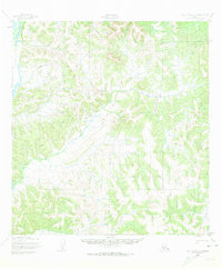
1952 Map of Holy Cross C-1
USGS Topo · Published 1974About this map
Innoko River winds through the northwestern corner of this territory, representing the primary waterway for an otherwise densely ridged interior. The landscape consists of a complex network of unnamed drainage basins and elevations that define the region south of the Innoko River. This mid-century survey, based on 1951 aerial photography, captures the area before modern development, showing the sheer isolation of the Alaskan wilderness. A solitary Winter Trail cuts across the northeastern hills, signifying the seasonal overland movement essential for travel and subsistence in this remote environment when the ground was frozen and navigable.
Find a feature on this map
2 named features on this map. Tap any name to fly to it.
Don’t see what you’re looking for? This feature index may not catch every label — zoom into the map to look around manually.
Map Details
Editions of this 1952 Holy Cross C-1 Map
2 editions found
Other maps of this area

1951 · Holy Cross
USGS Topo · 1:250,000

1951 · Iditarod
USGS Topo · 1:250,000

1952 · Holy Cross B-2
USGS Topo · 1:63,360

1952 · Holy Cross C-2
USGS Topo · 1:63,360

1952 · Holy Cross C-1
USGS Topo · 1:63,360

1952 · Holy Cross D-2
USGS Topo · 1:63,360

1952 · Holy Cross B-1
USGS Topo · 1:63,360

1952 · Holy Cross D-1
USGS Topo · 1:63,360

1952 · Holy Cross
USGS Topo · 1:250,000

1954 · Iditarod D-6
USGS Topo · 1:63,360