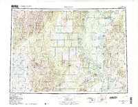
1952 Map of Holy Cross
USGS Topo · Published 1988About this map
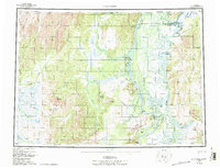
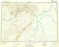
Yukon River navigation and remote airstrips define this mid-century portrait of West-Central Alaska. The confluence of the Anvik River and the Yukon serves as a primary corridor, supporting the settlement at Anvik and its adjacent Anvik Landing Strip. To the south, the village of Holy Cross sits near the base of the Holy Cross Hills, where the river network splinters into a complex system of sloughs including Deer Hunting Slough and Paimiut Slough.
Find a feature on this map
63 named features on this map. Tap any name to fly to it.
Don’t see what you’re looking for? This feature index may not catch every label — zoom into the map to look around manually.
Map Details
Editions of this 1952 Holy Cross Map
7 editions found
Other maps of this area
1947 · Russian Mission
USGS Topo · 1:250,000

1950 · Russian Mission
USGS Topo · 1:250,000
1950 · Sleetmute
USGS Topo · 1:250,000

1951 · Ophir
USGS Topo · 1:250,000

1951 · Marshall
USGS Topo · 1:250,000

1951 · Unalakleet
USGS Topo · 1:250,000

1951 · St Michael
USGS Topo · 1:250,000
1951 · Holy Cross
USGS Topo · 1:250,000
1951 · Iditarod
USGS Topo · 1:250,000

1951 · Holy Cross A-5
USGS Topo · 1:63,360