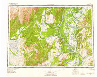
1952 Map of Holy Cross
USGS Topo · Published 1960About this map
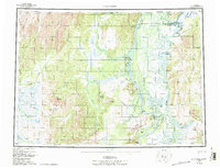
The confluence of the Yukon River and the Innoko River anchors this 1952 survey, which documents the remote terrain of western Alaska during the early postwar era. Settlements like Holy Cross, Anvik, and Shageluk appear alongside the intricate networks of the Bear Hunting Slough and Holikachuk Slough. The landscape is defined by the significant elevation of the Holy Cross Hills and Bonasila Dome, contrasting with the complex waterways and islands such as Carp Island and Horse Island.
Find a feature on this map
44 named features on this map. Tap any name to fly to it.
Don’t see what you’re looking for? This feature index may not catch every label — zoom into the map to look around manually.
Map Details
Editions of this 1952 Holy Cross Map
7 editions found

Other maps of this area

1947 · Russian Mission
USGS Topo · 1:250,000

1950 · Russian Mission
USGS Topo · 1:250,000

1950 · Sleetmute
USGS Topo · 1:250,000

1951 · Ophir
USGS Topo · 1:250,000

1951 · Marshall
USGS Topo · 1:250,000

1951 · Unalakleet
USGS Topo · 1:250,000

1951 · St Michael
USGS Topo · 1:250,000

1951 · Holy Cross
USGS Topo · 1:250,000

1951 · Iditarod
USGS Topo · 1:250,000

1951 · Holy Cross A-5
USGS Topo · 1:63,360