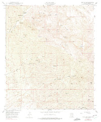
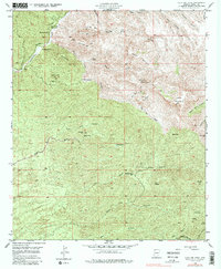
1949 Map of Holy Joe Peak
USGS Topo · Published 1975About this map
Aravaipa Creek winds through the northwestern corner of this territory, where early 20th-century agriculture and ranching once centered around Aravaipa Farms and the Mounierest Ranch. Evidence of an earlier frontier education is preserved at the Vale District Sch (Aban'd), while the surrounding peaks and canyons illustrate a landscape defined by rugged elevation and sparse water sources. High points like Holy Joe Peak and Table Mountain dominate the horizon, overshadowing a network of seasonal washes such as Brandenburg Wash and Zapata Wash. Small-scale resource extraction and livestock operations are visible through scattered landmarks like Oak Mining Mtn, the Reese Ranch, and various remote outposts including Dry Camp and Horse Camp. The presence of several inactive mines suggests a history of prospecting that had largely subsided by the mid-century field check.
Find a feature on this map
43 named features on this map. Tap any name to fly to it.
Don’t see what you’re looking for? This feature index may not catch every label — zoom into the map to look around manually.
Map Details
Editions of this 1949 Holy Joe Peak Map
5 editions found
Other maps of this area

1911 · Winkelman
USGS Topo · 1:125,000

1913 · Winkelman
USGS Topo · 1:125,000

1938 · Galiuro Mts
USGS Topo · 1:48,000

1938 · Klondyke
USGS Topo · 1:48,000

1943 · Galiuro Mts
USGS Topo · 1:62,500

1943 · Klondyke
USGS Topo · 1:62,500

1948 · Clark Ranch
USGS Topo · 1:24,000

1948 · Mammoth
USGS Topo · 1:62,500

1948 · Mammoth
USGS Topo · 1:24,000

1949 · Clark Ranch
USGS Topo · 1:24,000