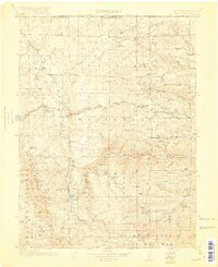
1920 Map of Home
USGS Topo · Published 1920About this map
Glendevey and Manhattan anchor this high-altitude landscape during the late 1910s, a period when the northern Colorado mountains were transitioning from frontier ranching to regulated forest management. The presence of the Stub Creek Ranger Sta, Lone Pine Ranger Sta, and Manhattan Ranger Sta underscores the early administrative reach of the Colorado National Forest and Arapaho National Forest. The map documents a rugged water network centered on the Cache la Poudre River and the Laramie River, which provided the vital lifeblood for remote outposts like The Rustic. Family ranching legacy is etched into the terrain through holdings such as Williams Ranch and Derby Ranch, while the Black Mtn School serves as a reminder of the isolated communities that once thrived along the State Road and the Prairie Divide.
Find a feature on this map
75 named features on this map. Tap any name to fly to it.
Don’t see what you’re looking for? This feature index may not catch every label — zoom into the map to look around manually.
Map Details
Editions of this 1920 Home Map
4 editions found

Other maps of this area

1895 · Laramie
USGS Topo · 1:125,000

1902 · Laramie
USGS Topo · 1:125,000

1905 · Sherman
USGS Topo · 1:125,000

1905 · Laramie
USGS Topo · 1:125,000

1905 · Mount Olympus
USGS Topo · 1:62,500

1906 · Medicine Bow
USGS Topo · 1:125,000

1906 · Laramie
USGS Topo · 1:125,000

1907 · Mount Olympus
USGS Topo · 1:62,500

1907 · Livermore
USGS Topo · 1:125,000

1908 · Laramie
USGS Topo · 1:125,000