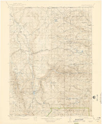
1920 Map of Home
USGS Topo · Published 1939About this map
The Laramie River and Cache la Poudre River headwaters define this high-altitude landscape along the Colorado and Wyoming border. Surveyed between 1914 and 1916, the map records a network of mountain settlements and early forest management infrastructure within the Roosevelt National Forest. Significant engineering is visible at the Laramie-Poudre Tunnel, a project designed to divert water between the two major drainage basins. Local life is anchored by small outposts like Glendevey, The Rustic, and Manhattan, the latter supported by a dedicated Manhattan Ranger Sta. Scattered ranching and educational sites, including the Black Mtn School and Bennett Ranch, appear alongside landmarks like Chambers Lake and the northern reaches of Rocky Mountain National Park. This survey captures the transition of the Larimer County backcountry from a remote ranching frontier into a managed national forest system during the early twentieth century.
Find a feature on this map
81 named features on this map. Tap any name to fly to it.
Don’t see what you’re looking for? This feature index may not catch every label — zoom into the map to look around manually.
Map Details
Editions of this 1920 Home Map
4 editions found

Other maps of this area

1895 · Laramie
USGS Topo · 1:125,000

1902 · Laramie
USGS Topo · 1:125,000

1905 · Sherman
USGS Topo · 1:125,000

1905 · Laramie
USGS Topo · 1:125,000

1905 · Mount Olympus
USGS Topo · 1:62,500

1906 · Medicine Bow
USGS Topo · 1:125,000

1906 · Laramie
USGS Topo · 1:125,000

1907 · Mount Olympus
USGS Topo · 1:62,500

1907 · Livermore
USGS Topo · 1:125,000

1908 · Laramie
USGS Topo · 1:125,000