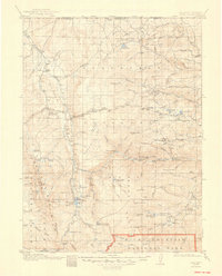
1920 Map of Home
USGS Topo · Published 1948About this map
Manhattan and Glendevey anchor this high-altitude landscape during the first decades of the 20th century, where the transition from ranching outposts to early forest management is evident. The northern edge of Rocky Mountain National Park meets the rugged drainage of the Cache la Poudre River, a region defined by scattered family holdings such as the Rugh Ranch, Bennett Ranch, and Williams Ranch. This period captures the infrastructure of the early U.S. Forest Service with multiple stations, including the Lone Pine Ranger Sta and Stub Creek Ranger Sta, positioned to manage the vast timber and watershed resources.
Find a feature on this map
72 named features on this map. Tap any name to fly to it.
Don’t see what you’re looking for? This feature index may not catch every label — zoom into the map to look around manually.
Map Details
Editions of this 1920 Home Map
4 editions found

Other maps of this area

1895 · Laramie
USGS Topo · 1:125,000

1902 · Laramie
USGS Topo · 1:125,000

1905 · Sherman
USGS Topo · 1:125,000

1905 · Laramie
USGS Topo · 1:125,000

1905 · Mount Olympus
USGS Topo · 1:62,500

1906 · Medicine Bow
USGS Topo · 1:125,000

1906 · Laramie
USGS Topo · 1:125,000

1907 · Mount Olympus
USGS Topo · 1:62,500

1907 · Livermore
USGS Topo · 1:125,000

1908 · Laramie
USGS Topo · 1:125,000