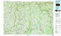
1986 Map of Honesdale
USGS Topo · Published 1989About this map
The Moosic Mountains and the northern reaches of the Catskill Mountains dominate this late-twentieth-century landscape, where the coal-mining heritage of the upper Lackawanna Valley meets the river-cut plateaus of the Delaware. In the south, the industrial corridor from Carbondale through Jermyn and Archbald follows the Lackawanna River, while the borough of Honesdale anchors the eastern region at the confluence of the Lackawaxen River and Dyberry Creek. The transition from industrial valley to rural highlands is marked by prominent elevations like Elk Mountain and the water-carved features of Archbald Pothole State Park.
Find a feature on this map
171 named features on this map. Tap any name to fly to it.
Don’t see what you’re looking for? This feature index may not catch every label — zoom into the map to look around manually.
Map Details
Editions of this 1986 Honesdale Map
2 editions found
Other maps of this area

1889 · Scranton
USGS Topo · 1:62,500

1891 · Scranton
USGS Topo · 1:62,500

1891 · Harveys Lake
USGS Topo · 1:62,500

1892 · Honesdale
USGS Topo · 1:62,500

1892 · Dundaff
USGS Topo · 1:62,500

1893 · Harvey Lake
USGS Topo · 1:62,500

1893 · Pittston
USGS Topo · 1:62,500

1893 · Scranton
USGS Topo · 1:62,500

1901 · Apalachin
USGS Topo · 1:62,500

1904 · Binghamton
USGS Topo · 1:62,500