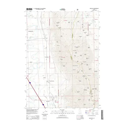
2014 Map of Honeyville
USGS Topo · Published 2014About this map
The Bear River winds through the western valley of this northern Utah landscape, providing a fertile corridor for the farming communities of Tremonton, Elwood, and Honeyville. To the east, the steep slopes of the Wellsville Mountains rise sharply within the Cache National Forest, reaching high points at Mendon Peak and Scout Peak. This geography creates a striking contrast between the irrigated agricultural grid of the valley floor and the complex drainage systems of the canyons above, such as Dewey Canyon and Hank Bell Canyon. Notable local landmarks include the Crystal Spring Resort and the Honeyville Cemetery, while the presence of numerous water sources like Honeyville Springs and Cold Spring Lakes underscores the vital role of hydrology in this arid region. The map also records the rural infrastructure of the early 21st century, from the Ut-38 highway to the network of local county roads serving isolated homesteads and flats like John Kidman Flat.
Find a feature on this map
134 named features on this map. Tap any name to fly to it.
Don’t see what you’re looking for? This feature index may not catch every label — zoom into the map to look around manually.
Map Details
Editions of this 2014 Honeyville Map
This is the sole edition of this map. No revisions or reprints were ever made.
Other maps of this area

1914 · Logan
USGS Topo · 1:125,000

1916 · Logan
USGS Topo · 1:125,000

1954 · Ogden
USGS Topo · 1:250,000

1954 · Brigham City
USGS Topo · 1:250,000

1955 · Bear River City
USGS Topo · 1:24,000

1955 · Mount Pisgah
USGS Topo · 1:24,000

1955 · Brigham City
USGS Topo · 1:24,000

1958 · Ogden
USGS Topo · 1:250,000

1958 · Brigham City
USGS Topo · 1:250,000

1960 · Ogden
USGS Topo · 1:250,000