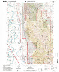
1998 Map of Honeyville
USGS Topo · Published 2001About this map
The Bear River winds through a complex irrigation and transport corridor in this late-twentieth-century study of the Bear River Valley. The Union Pacific railroad line and multiple water systems, including the Hammond Canal and various Gravel Pit operations, define the valley floor. Settlement is concentrated at Honeyville and Deweyville, where the presence of a Substation and Po indicates a developed rural infrastructure.
Find a feature on this map
103 named features on this map. Tap any name to fly to it.
Don’t see what you’re looking for? This feature index may not catch every label — zoom into the map to look around manually.
Map Details
Editions of this 1998 Honeyville Map
This is the sole edition of this map. No revisions or reprints were ever made.
Other maps of this area

1914 · Logan
USGS Topo · 1:125,000

1916 · Logan
USGS Topo · 1:125,000

1954 · Ogden
USGS Topo · 1:250,000

1954 · Brigham City
USGS Topo · 1:250,000

1955 · Bear River City
USGS Topo · 1:24,000

1955 · Mount Pisgah
USGS Topo · 1:24,000

1955 · Brigham City
USGS Topo · 1:24,000

1958 · Ogden
USGS Topo · 1:250,000

1958 · Brigham City
USGS Topo · 1:250,000

1960 · Ogden
USGS Topo · 1:250,000